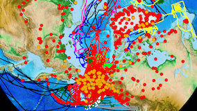
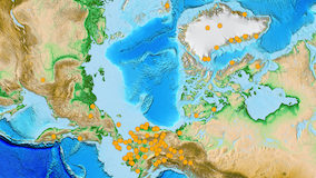
Welcome to ARMAP

ARMAP is a suite of online, interactive maps and services that support Arctic science.
  • Learn more about research projects recently funded in your region of interest or scientific discipline.
  • Explore available data or possible collaborations.
  • Use the online mapping tools to meet your own project's specific goals.
With 2D Maps and 3D Globes, users can navigate to areas of interest and explore or query information about field-based scientific research in the Arctic. Research sites are shown as points with links to details about project investigator, discipline, funding program, year, related websites, and other elements. ARMAP includes satellite imagery, other base maps, and map layers for places, roads, and natural features. Users can print or export maps for presentations, export selected data, select from a “map gallery” of predefined images, or link directly to a variety of database web services. With special emphasis on the International Polar Year (IPY), ARMAP strives to benefit scientists, science logistics experts, educators and the general public.

ARMAP 2D ARMAP in GE ARMAP 3D
Launch ARMAP 2D Launch ARMAP in Google Earth Setup ARMAP 3D
2D mapping application
Launch ARMAP 2D
ARMAP in Google Earth
Launch ARMAP in Google Earth   
Download Google EarthDownload Google Earth
ARMAP in ArcGIS Explorer
Setup ARMAP 3D

Which one should I use?

Find out which application best suits your needs here.

Recent News

06/2010 -ARMAP 3D updated for ArcGIS Explorer Build 1200
06/2010 -Presentation at the IPY Oslo Science Conference
05/2010 -Paper submitted to special issue of Geospatial Cyberinfrastructure and Polar Research
04/2010 -ARMAP continues to help develop interagency project tracking standard
03/2010 -ARMAP 3D updated for ArcGIS Explorer Build 900
03/2010 -Presentation at the State of the Arctic Conference
02/2010 -Demo for the AOOS Data Managenment and Coordination Committee
02/2010 -Presentation at Alaska Surveying and Mapping Conference
01/2010 -Poster presentation at the Alaska Marine Science Symposium
12/2009 -ARMAP helps develop interagency project tracking standard
12/2009 -Demonstration at the AGU Fall Meeting
09/2009 -AON-CADIS Web Map Viewer released
08/2009 -Collaboration on plans for an Arctic Spatial Data Infrastructure (ASDI) at the GeoNorth II Conference
08/2009 -Enabled access to scientific datasets in the Global Change Master Directory (GCMD)